Himalayas
Chenab River, Chandra River, Bhaga River, Spiti River of Himalayas, Himalaya Rivers, Rivers in Himalayan Mountain Range
The Himalaya, roof of the world, is a magic place where the magnificence of the world’s highest mountains is mirrored in the rugged beauty and unique culture of the people who live in their shadow.


Language Tanslation : Español | Français | Deutsch | Italiano | Português


Chandra & Bhaga River

Lahaul, Himachal Pradesh
Chandra River Valley, Bhaga River Valley And Chandrabhaga River Valley
Three Major Parts Of the Lahaul Region

Chandra River is one of the two rivers; the other one is Bhaga, which merges to form the Chenab in the Lahaul region of Himachal Pradesh. It rises in the snows lying at the base of the main Himalayan range in the Lahaul and Spiti district. The picturesque lake of Chandra Tal forms at this rivers source site.

River Chandra The Valley Of River Chandra
Valley of River Chandra is also known as “Rangloi”. This river originates from the southeast slope of the Baralacha La and turns abruptly west after traveling 48-km to flow another 64-km to meet with the Bhaga River at Tandi. Some of the main villages of this valley are - Khoksar, Sissu (also spelt as Sisu), Gondhla and Thorang. The area of the valley is about 2,600-sq-kms.

The Valley Of Bhaga
The Bhaga River rises in a small tarn called Suraj Tal. The river pursues a southwesterly course for about 64-km and joins Chandra at Tandi. The main villages in this valley are - Darcha, Peokar, Satingri, Jispa, Ghemur, Keylong and Khardong. The area of this valley is approximately 1,150-sq-kms.

The Valley Of Chandrabhaga
Both Chandra and Bhaga rivers meet at Tandi forming Chandrabhaga or Chenab, which flows northeast. It passes at Raoli, the last village of Lahaul, into Chamba district. Also known as Pattan Valley, the area beyond Thirot is called Chamba-Lahaul because of the of the Chamba supremacy in the past.

The valley area of Chndrabhaga in Lahau region is about 777-sq-kms. The soil and the people of this area are considered to be the richest in the region. Main villages over here include Tholand, Shasha, Lote, Jahlman, Thirot and Udeypur.

Spiti River

Spiti, Himachal Pradesh
Hansi And Dhankar Gompa

Spiti River 
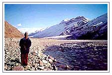
The valley of Spiti derives its name from the Spiti River, which rises just below the 16,000 ft high Kunzum Pass. After flowing for about 60 miles, it joins the Sutlej River near the village of Namgiya in Kinnaur district. En route it is fed several streams - Pin Cholmo, Gyundi, Rahtang, Ulah, Lungse, Mane, Surahi, Hanze, Tagling, Thumpa Lumpa, Kaza, Lingti, Parechu and Tabo.

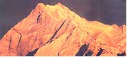
Valley Of Barren Splendour
Deep inside the inner folds of the Himalays, behind the greater Himalayan ranges lies the valley of Spiti. The sheer starkness of its beauty with its dramatic rock shapes and colours and its distinct cultural identity gives it a unique character that makes it stand apart from most of the other valleys of the Himalayas.

Huge mountains rise to very high elevations on either side of the Spiti River and its numerous tributaries. The valley has largely been influenced by the action of ancient glaciers. The river and its tributaries have deposited almost barren river terraces. The river attains peak discharge in late summers when snow on the mountains melts and it occasionally freezes in winter.

The main settlements that have come up along the Spiti River and its tributaries are Hansi and Dhankar Gompa.

(All Fields are compulsory)
All tours can be customized and extended as per requirements
Personal Information