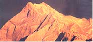
The Himalayas is one of the youngest mountain ranges in the world. Its
revolution can be traced to the Jurassic Era (80 million years ago) when the
world's landmasses were split into two: Laurasia in the Northern
hemisphere, and Gondwanaland in the southern hemisphere. The landmass which
is now India broke away from Gondwanaland and floated across the earth's
surface until it collided with asia. The hard volcanic rocks of India were
thrust against the soft sedimentary crust of Asia, creating the highest
mountain range in the world.
It
was a collision that formed mountain ranges right across asia, including the
karakoram, the pamirs, the Hindukush, the Tien Shan and the Kun Lun. The
Himalayan mountains, at the front of this continental collision, are still
being formed, rising and assuming complex profiles. For the ancient
geographer, the complexities of this vast mountain range were a constant
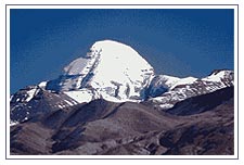
source of speculation. From the earliest accounts, Mt. Kailash was believed
to be the centre of the universe with the River systems of the Indus, the
Brahmaputra, and the Sutlej all flowing from its snowy ridges and
maintaining the courses which they had followed prior to the forming of the
Himalaya.
The Sutlej was able to maintain its course flowing directly from Tibet
through the main Himalayan mountain range to the Indian subcontinent, while the huge
gorges on both flanks of the Himalaya reflect the ability of the Indus and
the Brahmaputra to follow their original courses. The Indus flows west until
it rounds the Himalaya by the Nanga Parbat Massif, while the Brahmaputra
flows eastwards for nearly 1000-kms around the Assam Himalayas and descends
to the Bay of Bengal.
It was not surprising, therefore, that 19th century geographers experienced
formidable difficulties n tracing the River systems, and defining the
various mountain ranges that constitute the Himalaya. Even today, with the
advent of satellite pictures and state-of-the-art ordnace maps, it is still
difficult to appreciate the form and extent of some of the ranges that
constitute the Himalaya.
This
is the principal Himalayan mountain range dividing the Indian subcontinent from Nanga
Parbat in the west, the range stretches for over 2,000-km to the mountains
bordering Sikkim and Bhutan in the east. The west Himalaya is the part of
this range that divides Kashmir and Himachal Pradesh from Ladakh. The
highest mountains here are Nun and Kun. In Kashmir the subsidiary ridges of
the Himalaya include the North Sonarmarg, Kolahoi and Amarnath ranges.
Further east, the Himalaya extends across to the Baralacha range in
Himachal Pradesh before merging with the Parbati range to the east of the
Kullu valley. It then extends across kinnaur Kailas to the swargarohini and
Bandarpunch ranges in Uttaranchal. Further east it is defined by the snow
capped range North of the Gangotri glacier and by the huge peaks in the
vicinity of Nanda Devi, the highest mountain in the Indian Himalaya. In
Western Nepal the range is equally prominent across the Annapurna and
Dhaulagiri massifs, while in Eastern Nepal the main ridgeline frequently
coincides with the political boundary between Nepal and Tibet.
The
major passes over the main Himalaya range include the Zoji la, at the head
of the Sindh valley; the Boktol pass, at the head of the Warvan valley; the
Umasi la in the Kishtwar region; and Thekang la and the Shingo la between
Lahaul and the Zanskar region of Ladakh. It also includes the Pin Parbati
pass between Lahaul and the Zanskar region of Ladakh. It also includes the
Pin Parbati pass between the Kullu valley and Spiti, while in Kinnaur it is
traversed when crossing the charang la in the Kinnaur Kailash range.
In Uttaranchal, roads are being constructed to the main places of
pilgrimage in the heart of the Himalaya. These include Yamunotri and the
source of the Yamuna River, Gangotri at the head of the Bhagirathi valley,
Kedarnath at the head of the Mandakini valley, and Badrinath in the
Alaknanda valley. There are, however, many trekking possibilities across the
mountain ridges and glacial valleys including tose bordering the Nanda Devi
sanctuary.
The main Himalaya range extends east across central Sikkim from the huge
Kangchenjunga massif, which includes Kangchenjunga I, the world's third
highest peak. The east Himalaya is breached by the headwaters of the Tista
River, which forms the geographical divide between the verdant alpine
valleys to the south and the more arid regions that extend North to Tibet.
Trekking possibilities are at present confined to the vicinity of the
Singali ridge, an impressive range that exxtends south from the main
Himalayan mountain range and forms the border between India and Nepal.
In Darjeeling the treks include the route along the southern extremity of
the Singali range, while in Sikkim the trails out of Yuksom explore the
ridges and valleys to the south to the Kangchenjunga massif.
The
Pir Panjal Range lies south of the main Himalaya at an average elevation of
5,000m. From Gulmarg in the North west it follows the southern rim of the
Kashmir valley to the Banihal pass. Here the Pir Panjal meets the ridgeline
separating the Kashmir valley from the Warvan valley. From Banihal the Pir
Panjal sweeps south-east to Kishtwar, where the combined waters of the
Warvan and Chandra Rivers meet to form the Chenab River, one of the main
tributaries of the Indus.
Passes In Pir Panjal
The main passes over the Pir Panjal include the pir panjal pass due west of
Srinagar, the Banihal pass which lies at the head of the Jhelum River at the
southern end of the Kashmir valley, and the sythen pass linking Kashmir with
Kishtwar. In Himachal Pradesh the main passes are the Sach which links the
Ravi and the Chandra valleys, and the Rohtang, which links the Beas and
Kullu valleys with the upper Chandra valley and Lahaul. Roads are
constructed over all these passes.
The Banihal is now tunnelled and another road has been made over the Sythen
pass in Kashmir and the Sach pass in Himachal Pradesh. For trekkers there is
still the attraction of the Kugti, Kalicho and Chobia passes between the
Ravi valley and Lahaul, and the Hampta pass links the Kullu valley with
Lahaul.
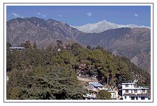
The
Dhaula Dhar range lies to the south of the Pir Panjal. It is easily
recognised as the snow-capped ridge behind Dharamsala where it forms the
divide between the Ravi and the Beas valleys. To the west it provides the
divide between the Chenab valley below Kishtwar and the Tawi valley which
twists south to Jammu. This is the range crossed at Patnitop on the
Jammu-Srinagar highway. To the east it extends across Himachal Pradesh
forming the high ridges of the Largi gorge and extending south of the Pin
Parvati valley before forming the impressive ridgeline east of the Sutlej
River. Thereon it forms the snow capped divide between the Sangla valley and
upper tons catchment area in Uttaranchal, including the Har Ki Dun Valley.
Beyond the Bhagirathi River it forms the range between Gangotri and
Kedarnath before merging with the main Himalaya at the head of the Gangotri
glacier.
There are many attractive trekking pases over the Dhaula Dhar. These
include the Indrahar Pass North of Dharamsala: and in Kinnaur, the Borasu
pass linking the Sangla valley to Har-ki-Dun in Uttaranchal.
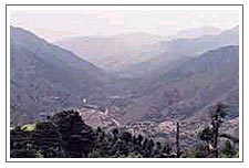
The Siwalik Hills, also known as Shiwalik Hills, lie to
the south of the Dhaula Dhar, with an average elevation of 1,500 to 2,000m.
They are the first range of hills encountered en route from the plains and
are geologically separate from the Himalaya. They include the Jammu hills
and Vaishno Devi, and extend to Kangra and further east to the range south
of Mandi. In Uttaranchal , they extend from Dehra Dun to Almora before
heading across the southern borders of Nepal. Most of the range is crossed
by a network of roads, linking the Northern Indian plains with Kangra, the
Kullu valley, Shimla and Dehradun.
The
Zanskar range lies to the North of the main Himalayan Mountain range. It forms the backbone
of Ladakh south of the Indus River, stretching from the ridges beyond
Lamayuru in the west across the Zanskar region, where it is divided from the
main Himalaya by the Stod and Tsarap valleys, the populated districts of the
Zanskar valley. The Zanskar range is breached where the Zanskar River flows
North, creating awesome gorges until it reaches the Indus River just below
Leh.
To the east of the Zanskar region the range continues through Lahaul &
Spiti, providing a complex buffer zone between the main Himalaya and the
Tibetan plateau. It continues across the North of Kinnaur before extending
west across Uttaranchal, where it again forms the intermediary range between
the Himalaya and the Tibetan plateau, which includes Kamet, the second
highest peak in India. The range finally peters out North east of the Kali
River - close to the border between India and Nepal.
On the Zanskar range, the Fatu La, on the Leh-Srinagar road, is considered
the most easterly pass; while the Singge La, the Cha Cha La and the Rubrang
La are the main trekking passes into the Zanskar valley. For the hardy
Ladakh trader, the main route in winter between the Zanskar valley and Leh
is down the icebound Zanskar River gorges. Further to the east, many of the
Zanskar range passes to the North of Spiti and Kinnaur are close to the
India-Tibet border, and are closed to Trekkers
The ladakh range lies to the North of Leh and is an
integral part of the Trans-Himalayan range that merges with the Kailash
range in Tibet. The passes include the famous Kardung La, the highest
motorable pass in the world, while the Digar La to the North east of Leh is
at present the only pass open to trekkers..
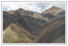
The East Karakoram Range is the huge range that
forms the geographical divide between India and Central Asia. It includes
many high peaks including - Teram Kargri, Saltoro Kangri and Rimo, while the
Karakoram Pass was the main trading link between the markets of Leh, Yarkand
and Kashgar. At present this region is closed to trekkers, although a few
foreign mountaineering groups were permitted to climb there in the last
decade.